


Lac Ste Hélène-G2

Valmeinier
User
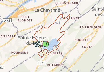

Length
8.7 km

Max alt
351 m

Uphill gradient
157 m
Km-Effort
10.8 km

Min alt
255 m

Downhill gradient
160 m
Boucle
Yes
Creation date :
2020-03-19 12:29:17.668
Updated on :
2020-03-19 12:29:35.796
2h19
Difficulty : Medium

FREE GPS app for hiking
 SityTrail
IGN / Geographical institutes
SityTrail Plus
The world is yours!
About
Trail Walking of 8.7 km to be discovered at Auvergne-Rhône-Alpes, Savoy, Les Mollettes. This trail is proposed by Valmeinier.
Positioning
Country:
France
Region :
Auvergne-Rhône-Alpes
Department/Province :
Savoy
Municipality :
Les Mollettes
Location:
Unknown
Start:(Dec)
Start:(UTM)
270967 ; 5040215 (32T) N.
Comments